The Center for Spatial Research, with Urban Omnibus, has just published an interactive map that locates the diverse sites and institutions that comprise the New York City criminal justice system. The map is part of Urban Omnibus’s new series, The Location of Justice, which examines “the pervasive and often overlooked infrastructure of criminal justice in New York and the spaces that could serve a more just city.”
CSR researchers and students and steering committee members participate in map-a-thon to assist with the humanitarian crisis in Puerto Rico featured by PBS NewsHour: "Volunteers are helping Puerto Rico from home, with a map anyone can edit"
CSR researchers and students participate in map-a-thon to assist with the humanitarian crisis in Puerto Rico featured by The New York Times: "A Mapathon to Pinpoint Areas Hardest Hit in Puerto Rico."
This course provides an introduction to critical mapping theory and geographic information systems tools. Of particular interest to Humanities students, we will address both historical and contemporary questions of space and mapping. Through the use of open-source GIS software (qGIS) and data (OpenStreetMap) students will learn how to critically use mapping tools and geographic data for spatial analysis and representation.
Michelle McSweeney and Dare Brawley will offer two introductory GIS workshops as part of this year’s New York City Digital Humanities Week. NYCDH Week offers students, faculty, librarians, and researchers the opportunity to take advantage of workshops in the digital humanities offered at universities across the city. All workshops are free and open to the public.
A call for applications. The Center for Spatial Research and the Dean of Humanities invite interested Columbia University faculty to participate in Mapping for the Urban Humanities: A Summer Institute. During the two-week Mellon-funded institute faculty will learn key skills in mapping, data visualization, and data collection that they can incorporate into their research and teaching. Space is limited. Interested faculty are encouraged to apply by January 27, 2017.
Dr. Daniel Cooper of Adler University and Dr. Ryan Lugalia-Hollon, a writer and strategist, drew on our work on Million Dollar Blocks to map the incarceration landscape in Chicago. They used data collected by the Chicago Justice Project and built on research methods developed by the Spatial Information Design Lab.
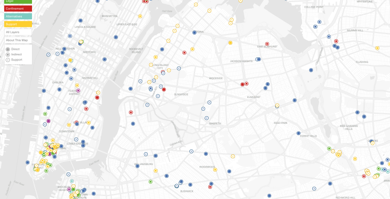
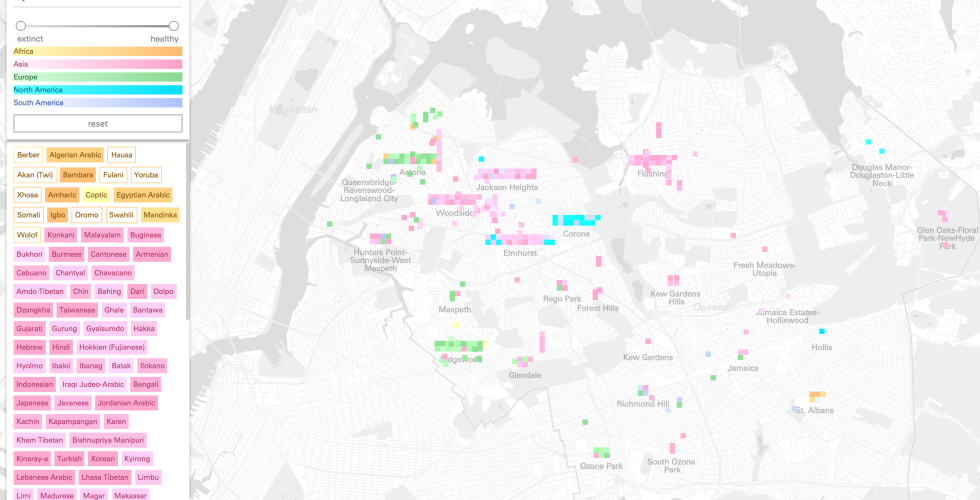
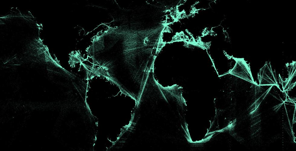
Ninety percent of all goods worldwide are moved by ship, but shipping is mostly invisible. More than 300 million Metric Tons of energy are shipped in and out of the United States each year, in 60,000 shipments. This project presents the ports and paths of the 2.7 billion Metric Tons of energy shipped through more than 90 US ports from 2002 - 2012. Using data assembled by Thomson Reuters, Port to Port maps global oil shipping routes as well as other forms of energy navigating ocean territories to and from the United States. Using D3 as an interactive web platform we designed a map interface that is scaled globally while embedded with local stories about energy movement from port to port. Data can be viewed across time, which reveal changes in patterns of movement as the geopolitics, price of oil, and conditions at specific ports change.
Pagination
- Previous page
- Page 2